- Given enough time and money engineers can solve any problem.
- There’s never enough time or money.
Here are some actual engineering rules.
- You have available to you the factors of Fast, Good, and Cheap. You are allowed to select two; the third is a byproduct. https://en.wikipedia.org/wiki/Project_management_triangle
Design something quickly and to a high standard, but then it will not be cheap.
Design something quickly and cheaply, but it will not be of high quality.
Design something with high quality and cheaply, but it will take a relatively longer time.
And that’s further constrained by the following two rules: - Some projects can only be completed so fast. It still takes 9 months to make a baby, no matter how many women you add to the project. Another way of saying this is, 9 women cannot make a baby in one month. https://en.wikipedia.org/wiki/The_Mythical_Man-Month
- Adding people, to an already-late project, makes the project finish even later. [ibid] In truth, all you can really do to speed up development once you’re staffed up and the project is in progress involves removing features, or decreasing quality. A common request is, “Let’s say we shorten the testing phase.” This results in more bugs, guaranteed.
These are truth for software engineering projects. I can’t speak for the guys working with the molecules, but I suspect some of the same limitations apply.
Great interview.
Not sure if this is of any interest. Nov 1974 California Water Project Storage Facilities Bulletin.
Oroville Dam details start on page 63
https://archive.org/stream/zh9californiastatew2003calirich#page/62/mode/2up
thc0655 wrote:
1. Given enough time and money engineers can solve any problem.
2. There's never enough time or money.
davefairtex wrote:
3) Adding people, to an already-late project, makes the project finish even later. [ibid] In truth, all you can really do to speed up development once you're staffed up and the project is in progress involves removing features, or decreasing quality. A common request is, "Let's say we shorten the testing phase." This results in more bugs, guaranteed.
These are truth for software engineering projects. I can't speak for the guys working with the molecules, but I suspect some of the same limitations apply.
Someone beam up Scotty!
https://www.metabunk.org/data/MetaMirrorCache/7bfb5f803e01e6e36c5d0cf583097f44.jpg
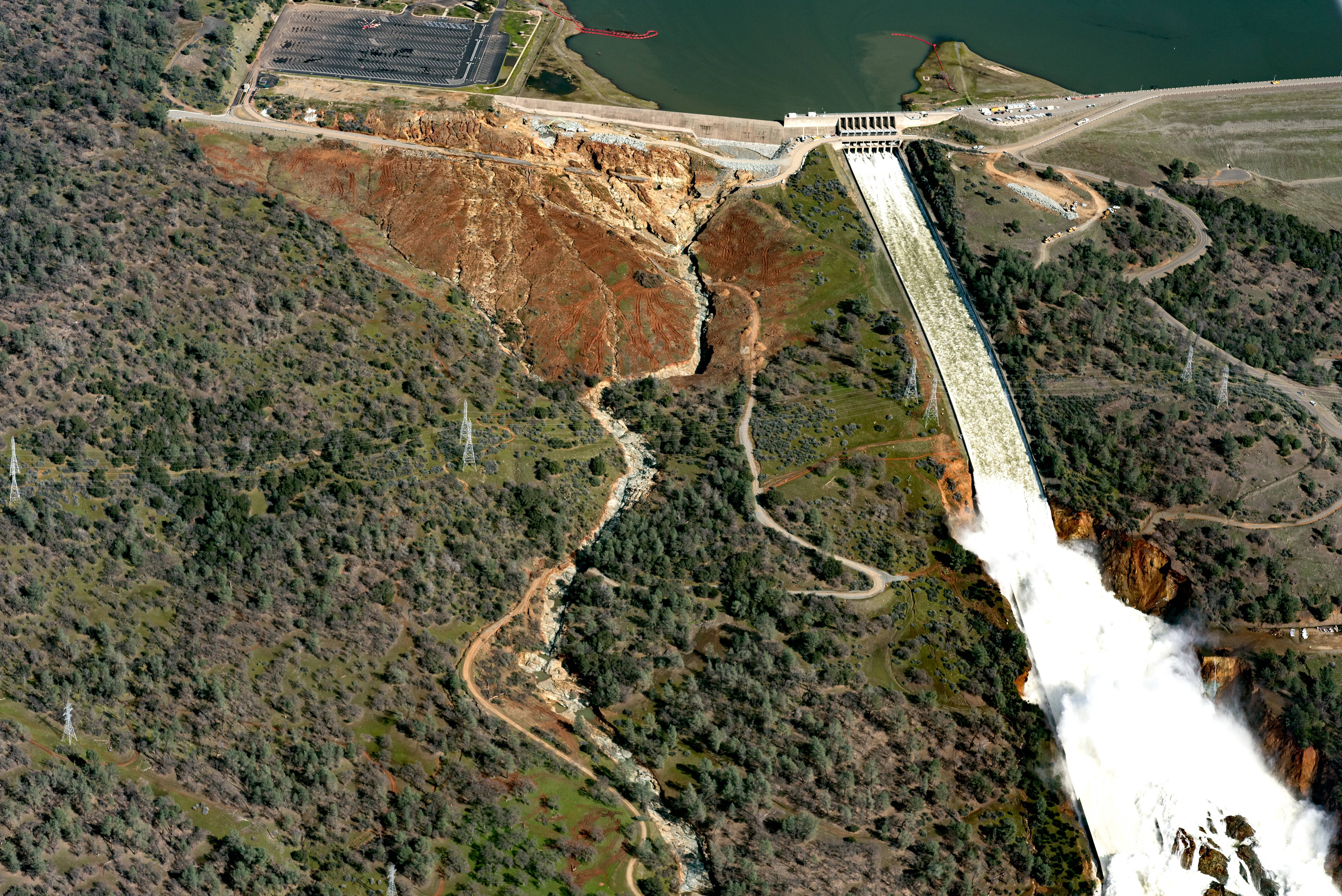
This is a high res photo taken (apparently) yesterday.
If you look below the two pylons on left hand side of the main spillway, where there is a bend in the dirt road and below, there are huge cracks running all the way down the hillside.
If this earth was to slip downwards, would it potentially block the river and what impact would this have on the toe of the dam?
Thank you
Looks like it’s going to be pretty wet. The Canadian model pretty much agrees.

Given the evacuation order lift…using this time to move anything important out of the potential flood zone would be a prudent course of action IMO.
As well as leaving prior to the onset of heavy rains.
YLMMV.
I didn’t create this, but wanted to pass it along.
https://github.com/axibase/atsd-use-cases/blob/master/OrovilleDam/README.md
“Let’s begin by gathering current data for the Oroville dam from cdec.water.ca.gov. This dataset can be found here.
Data is collected hourly for the Oroville dam for the following metrics:
Reservoir Elevation (feet)
Reservoir Storage (acre-foot)
Dam Outflow (cubic feet/second)
Dam Inflow (cubic feet/second)
Spillway Outflow (cubic feet/second)
Rain (inches)”
CampoGirl wrote:
https://www.metabunk.org/data/MetaMirrorCache/7bfb5f803e01e6e36c5d0cf583097f44.jpg
This is a high res photo taken (apparently) yesterday.
If you look below the two pylons on left hand side of the main spillway, where there is a bend in the dirt road and below, there are huge cracks running all the way down the hillside.
If this earth was to slip downwards, would it potentially block the river and what impact would this have on the toe of the dam?
Thank you
(cross-posting from the other Oroville article)
I did some research online looking at photo’s. Found some interesting things…
In this photo you can see the drains actively flowing above the failure site.They cease to flow below the failure, indicating that the water is no longer under pressure and has been relieved by the failure of the spillway surface. They also appear to flow stronger the higher up the face they are. This would be because some of the water is released along the spillway side curtain, as seen in a following photo. I think this leak has been in place for a long time, and has only recently exposed itself in a surface failure. They previously attempted to patch the crack, without solving the under surface situation.
This image seems to support the increased flow observations from earlier. Also note no flow below the failure point. This is only on the “Left” side of the spillway, the right side still flows below the failure site. Also, lots of flow….without much spillway pressure… possibly indicating a pool breach pressure source.
http://www.sacbee.com/news/local/27n2uk/picture131475559/binary/spillwaydamage
Note, flow continues past failure on left side of picture. Does not appear that pressure is coming from spillway source. Not a good sign.
http://www.sacbee.com/news/local/3ll8fd/picture131475549/binary/KGspillwaydamage
The latest forecast shows roughly 10 inches of rain will fall in Oroville over the next week, and likely more in the surrounding environs that feed into the dam:

Tapping into energy resources comes with costs. Which one will be next?
Coming to a local oil field near you!
http://calgaryherald.com/business/energy/energy-watchdog-shuts-down-lexi…
Great Photo CampoGirl!
That reddish line looks more like plastic perforated construction limit fencing - more for personnel safety. The “cracks” below the hairpin bend look more like gully erosion. With all the recent rains, water likely collected along the roadway to the hairpin and then took the path of least resistance downhill.
The soils are variable, but fairly shallow. As Scott noted, there is plenty of “rotten” weathered rock. Weathered rock isn’t as competent and erodes much more quickly. The weathering generally progresses from the surface along joints or cracks in the rock where water can percolate more easily. Weathering generally takes place over long time spans. Nonetheless, fast moving water dislodges weaker rock and batters more competent rock with it.
Although the situation here is far from desirable, the water coming off the spillway is running clear. That tells me that it is reaching a point of stasis. Unless the flow rate through the spillway increases, it is likely stabilizing. That’s as good as can be expected at this time.
Looking near the left side of the emergency spillway, there is a rounded erosion feature that is being “repaired” by boulders and a concrete pumper (equipment with segmented green lines.) Time2Help posted an aerial photo that showed this feature a couple of days ago in the daily digest. That feature is likely what caused officials to issue the evacuation order. Angular “V” shaped features are more common in competent rock. Rounded erosion features like this are indicative of foliated (platy) weak rock. This localized weaker rock could easily extend under the emergency spillway. If water flowing over the emergency spillway continued to erode this feature toward the weir, it could easily undermine the weir and tunnel to the reservoir. That would have been potentially catastrophic! The emergency spillway has other undesirable attributes. This was just the most noticeable. They need to do whatever they can to keep from using the emergency spillway.
We’re not out of the woods yet, but the situation isn’t as dire as it was. If I were advising the authorities, I would suggest building a temporary dam (with a sequence of boulders, cobbles, gravel, and an impermeable membrane) downstream of the power house and then pump the tail water out. This would prevent the sloshing tail water from further damaging the power house and the toe of the dam. It would also allow more discharge through the spillway (if possible/necessary) to keep water from flowing over the emergency spillway.
On a positive note, this crisis will force other dam owners to be more vigilant. Deferred maintenance will no longer be deferred. Just 2 cents from a retired “dirt” engineer,
Grover
BTW, Scott’s explanations were wonderful - easily understood and technically founded.
Edit - peterkukendall wrote on the “Oroville Dam Threatens to Collapse” thread that operations are ongoing to get the power plant back on line. My suggestion to dewater the power house can be ignored.
Dave:
I whole heartedly agree - this was a serious and tenuous event. It was very poorly conveyed - Thanks for the kind words, too.
Scott
Great Picture! You are exactly right. In fact, the loss of trees and soils, rock, and debris already experienced with this low-flow discharge has choked the stream and caused backup. If the Em. Spillway is used to move significant amounts of water there will be losses of earth, rock, and debris again downstream. I imagine, because of our recent experience, that this will result in flooding of the base of the dam and scour across the stream. I think generally that your assessment is accurate,
Scott
Hello All
I am first going to say, thank you all for the intelligent, well-written, consideration of this issue. The nice comments mean the world to me, and have made my day today. As I write, the rain is falling across the watershed. It is a horrifying and unacceptable evolution that we have seen develop. Lets all hope that the dam holds. It is an odd thing, playing Chicken Little to an ever decaying infrastructure, one must warn because it is honorable to do so. Still, the bad part may, out of frustration, begin to actually hope for the worst, to allow, at last a universal understanding, to get it over with, so we may start, at last, to make things right.
I have torn the tiny devil from my shoulder and have stomped him thoroughly. I am listening to the little angel that sits on the other. If we must suffer a dam breach in order to become responsible, let it not be this dam. There are too many good people in its shadow. The water is too precious, and the ecology of the region too valuable. Perhaps, if mankind cannot learn without tragedy, let it be on some remote mountainside or coastal area, where no one must die, where no home is lost.
Thank you for your thoughts and assistance, and for being the informed minority. I am so honored to be a part.
Scott Cahill
There remains a flash flood watch in effect at Oroville (issued last night 2/15):
FLASH Flood Watch IN EFFECT FOR THE Auxiliary SPILLWAY AT OROVILLE DAM IN BUTTE COUNTY CA... The National Weather Service in Sacramento CA has issued a Flash Flood Watch for the Auxiliary Spillway of Oroville Dam in Butte County. Officials managing the incident indicated that the situation has stabilized sufficiently to lift mandatory evacuation orders. However, voluntary evacuation notices are in place. Flash Flood Watch for Auxiliary Spillway of Oroville Dam on the Feather River in Butte County California. Watch will remain in place until the situation changes. Residents are urged to follow emergency instructions from local authorities. (Source)A 'watch' is a level below 'warning.' The evacuation 'order' remains voluntary. It just means that the new storms are being monitored very carefully. If I lived in the direct floodplain there I would probably just pack up my most valuable things, secure everything else and go hang out on higher ground until the next storm passes.
The latest GFS run continues to show storm after storm affecting the area for the next 15 days. Looks like a lot of rainfall is on tap. I do not know how much needs to fall within a specific period of time to present additional problems, but many inches appear to be in the cards over the upcoming days for the areas that will run off and pour into the lake. And we had better hope they don’t have an earthquake any time soon.
I would think that after the rains stop and the river level goes down, there will be a great opportunity to do some gold panning. All that erosion and silt has to result in re-depositing some gold flecks in the area. With all the heavy rains in Northern CA this winter, I’ve heard that those into gold panning will but out in force this summer. ![]()