I just came upon a reference to the Arkstorm from the 1860’s on the west coast, something that I had never heard of before, so I thought I’d share on the Oroville discussion. I wonder if this was the type of event that the emergency Oroville spillway was supposed to, by design, accommodate, remembering hearing how the emergency spillway nearly collapsed during the spring flooding only after it was subjected to a small percentage of its design capacity.
Makes one contemplate the scale of the catastrophe should a similar arkstorm-like event would occur - would be greater than Harvey, I suspect. Think multiple dam, levee, and road infrastructure failures.
https://en.wikipedia.org/wiki/Great_Flood_of_1862
Based on these two videos, it looks like the spillway work is proceeding apace, and that the repairs have been taken seriously.
There are machines and workers crawling all over the place in these videos, and they are running round the clock shifts. The first video notes that twice as much concrete as initially estimated was needed…over 870,000 cubic yards due to solid bedrock being a lot further down than thought.
So the price to fix the spillways has also doubled to more than $500 million. A not insignificant number!
Here is a drone flyover of the Oroville Dam spillway on October 23, 2017. It is only 2:03 minutes long. The roller compacted concrete (RCC) has just about completely filled the plunge pool and they have less than 10’ of vertical placement left to tie into the relatively undamaged upper spillway. As Chris noted, the work appears to be of high quality. What would we expect for $half-a-billion +/- so far?
http://www.mercurynews.com/2017/08/31/oroville-dam-green-spot-no-cause-for-alarm-dwr-says-in-new-report/ The spot is not a cause for worry because, in part, it is dry in the summer and green in wet months, every year, the 28-page report states. It also says seepage measurements at the base of the dam have stayed low since original construction. “If any water did make its way through the dam’s core, it would be intercepted by a vertical drain, preventing it from flowing to the downstream area of the dam where the vegetation is located,” Mellon wrote in an email. He said the vegetation area is visible in wet months because rain settles there, and as to why it sits in this one spot, splayed horizontally — it has to do with the way materials were placed when the dam was built. “Dirtier” material was put there unintentionally by a contractor, he said. “The rainfall hits stratified layers, so it can’t go down,” Harder said. “There is no safety problem that exists.” Harder said if differential settlement were to occur, the original designers planned for a separation of five feet and in the last 50 years, there has been a shift of 10 inches. He also added that the “green spot” has been there since the dam’s original construction, before the reservoir was filled, something that DWR officials have previously stated. “There is hardly any water seeping through,” he said. “(DWR has) been taking manual readings over the last 50 years.” Seepage through the weir has been measured at 10 gallons per minute during the dry season, which the report notes is “extremely low for a dam this size” and at 100 gallons per minute during wet periods, which has been consistent since original construction, according to the report. Harder wanted to emphasize that several independent groups have reviewed the “green spot” and determined it not to be a safety issue. He said several more reports on the area would be released in a year and a half or sooner.Look at post#5 to see a stylized cross sectional view of a typical earthen dam. Earthen dams have a clay core that impedes water flow and various gradations of coarser materials for filtering and armoring to protect the clay core. Unless DWR is lying about how much water flows through the dam, it is a nonissue. Installing working piezometers (which measure water pressure) in and surrounding the green spot would be prudent and would silence the critics. Focusing on this issue reduces the credence I give to Scott Cahill and Bob Bea.
In Post#10, Scott Cahill wrote:
A quarter of a Billion or so has been sent to CA to plug the holes in the Oroville Dam by the Federal Government. The Billions of wasted money are the result of irresponsible stewardship of a major element of infrastructure and a culture that is a failure.
Already hundreds of thousands of people's lives have been put in jeopardy. When confronted with their failure they have misled and lied and redacted documents. When men like Dr. Bea offer help they ignore them, then marginalize their words.
Even with this horrible bungling of responsibility, I, like Dr. Bea see nothing improving. My words speak for themselves and time will show who was right and who was wrong.
California DWR released this drone video of the Oroville Dam spillway taken November 1st at 5:30 PM. The first phase of work on the spillway is mostly completed. They have isolated portions to finish and remove equipment to have the spillway ready for use if necessary this winter. That likely won’t happen because the lake level is at about 700’ elevation and the reservoir has more than 2 million acre feet of storage capacity before the reservoir level gets high enough to require the spillway to be needed.
Other work will continue throughout the winter season - weather permitting. Mostly, on the secant cutoff wall in the emergency spillway. Next year, phase II will rebuild the upper section and armor the middle section. There will also be work on the head gates, but I haven’t seen or heard what exactly will be done to correct deficiencies. That will likely be decided this winter while engineers can focus on that instead of day-to-day construction activities.
The work that has been performed has cost on the order of $500 million. Unfortunately, about 75% of this cost will be covered by FEMA. That means that everybody in the US has had tax dollars siphoned away to pay for this preventable disaster. Had DWR performed needed work in a timely fashion, the cost would have been less than 10% of this; however, managers are under pressure to make a profit … and maintenance expenditures eat into profits. What a shame.
Unless political pressure (to keep the dams safe) exceeds the profit seeking, things will never change. Look at PP threads concerning the disaster as a microcosm. When it was a crisis, there was plenty of discussion about it. When it got down to the mundane repair operations, interest quickly flitted to the next apparent flame of public interest.
I appreciate that people like Scott Cahill and Robert Bea are doing what they can to point out deficiencies in maintenance; however, not every problem has the same level of importance. For instance, focusing on “the green spot” allows dam managers to discount their dire warnings. Not every problem is an 11 on a scale of 1 to 10.
Grover
I saw this interesting read of all places on weather.com related to the California Arkstorm - amazing stuff, although considering the source, it of course has a sensationalistic bent. In my previous post on this I contemplated the scale of the damage that would result. This article addresses this questions
http://features.weather.com/us-climate-change/california/
PaulJam wrote:
I just came upon a reference to the Arkstorm from the 1860's on the west coast, something that I had never heard of before, so I thought I'd share on the Oroville discussion. I wonder if this was the type of event that the emergency Oroville spillway was supposed to, by design, accommodate, remembering hearing how the emergency spillway nearly collapsed during the spring flooding only after it was subjected to a small percentage of its design capacity.
Makes one contemplate the scale of the catastrophe should a similar arkstorm-like event would occur - would be greater than Harvey, I suspect. Think multiple dam, levee, and road infrastructure failures.
https://en.wikipedia.org/wiki/Great_Flood_of_1862
Current level is 889 ft, atmospheric storm predicted for the next few days. Is the dam repair complete? Is it ok now by all accounts?
Great question Cariolian, and my response is that the work performed on it certainly seemed comprehensive and complete. At least on the spillway and overflow areas.
However, with that said, the levels are certainly very high:

http://oroville.lakesonline.com/Level/
The areas that remain a concern here, to me, are the spots on the right face of the dam itself that showed signs of leakage and erosion. As far as I am aware, no work was done on that area, but perhaps it was and not well reported on.
Still, after spending a whopping $1.1 billion I’m pretty confident that the main spillway is good to go, and I’m pretty sure the overflow area was well tended to.
However, should the overflow (“emergency spillway”) be called into use, I would monitor the situation myself as well as possible, looking for any discolored water or other signs of erosion at the base. That automatically comes into play at 901 ft…so a good storm dropping lots of snow-melting rain could get there I would think.
Probably worth keeping an eye on the right dam face too.
Cariolian Starfighter wrote: Current level is 889 ft, atmospheric storm predicted for the next few days. Is the dam repair complete? Is it ok now by all accounts?You are correct that the lake is at its highest level since the disaster 2 years ago. The DWR tested the spillway last month to see how the repairs would perform in actual use.
https://www.chicoer.com/2019/05/14/spillway-concerns-dwr-sheriff-kory-honea-say-no/. The approaching storm is expected to drop at least 1.5 inches of rain on the valley floor, according to the National Weather Service. Currently the elevation of the water in Lake Oroville stands at 889 feet elevation — 11 feet below the top — while outflows to the Feather River are 9,500 cubic feet per second, according to the state’s data exchange center. In regards to concerns the storm could bring several inches of rain into the lake forcing the spillway to release water, the community update from the DWR states: “Forecasts and weather can change rapidly, and DWR will notify the public and media if the main spillway needs to be used to manage reservoir levels … DWR is targeting high lake levels through spring and summer in accordance with normal state and federal regulations, which is good news for local recreation and for statewide water supply.”The reservoir is 95% full. There is still ~175,000 acre feet of storage available in the reservoir. Since the water is used for agriculture, recreation, domestic uses, etc., the goal is to have as much available as possible for these uses. Remember that California doesn't always get such copious amounts of moisture. Winter storm season would normally be done by now. Although the snow pack is much deeper than normal, it melts in a predictable fashion. There will be plenty of time for DWR to adjust outflows to accommodate most inflow anomalies. The Hyatt power plant can process up to 17,500 CFS while the spillway can easily handle 100,000 CFS. (Look at the graph in Chris' response and see how rapidly the lake level dropped in 2017.) Lots of money was spent to ensure the spillway could handle that amount of flow without any significant issues in the short to medium term. The "Green Spot" isn't something I'm overly concerned about. It isn't ideal, but it isn't necessarily catastrophic. Earthen dams are designed to leak at a very slow rate. That is what keeps the clay core from desiccating and cracking. The armoring upstream and downstream keep the core from eroding. Material having specified gradation qualities is placed in zones with finer grained material (fine sands) closest to the core and coarser material (boulders) near the dam surface. Each zone is graded to keep the adjacent inside zone from eroding while letting water pass through relatively unhindered. Because of the variable nature of soils, there can be local areas where water could find its way to the dam's surface. It could come from a nearby spring or through the dam itself. It doesn't take much subsurface water to grow grass this time of year. Historical photos show that the green spot was evident shortly after the reservoir was first filled. It isn't a new phenomenon. If it were a new formation, then it would be much more worrying - what changed to cause this to occur??? I would install piezometers to ensure water pressure wasn't building up and then leave it alone. Only if water pressure built up beyond a predetermined level would it be a concern. I'm much more concerned with what repairs were made to the spillway head gates. Dr. Robert Bea's report showed many points of structural concern. Scott Cahill noted that the repairs were kept secret. That doesn't make sense to me but lots of the anti-terrorist stuff doesn't make sense to me. Because of this, we have to trust the very agency who - through failed maintenance - allowed the catastrophe to happen in the first place. That doesn't leave me with a warm and fuzzy feeling; however, humans are really good at closing the barn door after the horses have escaped. Since there was this catastrophe, the officials will not want any "accidents" to occur on their watch. They'll be hyper vigilant to keep that from happening. Until a new crop of officials come through the system, complacency won't be tolerated. Grover
Just for fun, here are two live feeds from the top and the bottom of hte Oroville dam spillway:
Top:
http://www.parks.ca.gov/live/lakeorovillesra_spillwaytop
Bottom:
http://www.parks.ca.gov/live/lakeorovillesra_spillway
Next, the dam may well be sorely tested this next week or two.
Not one, not two, but three atmospheric rivers are headed for NorCal and the next 10-12 days are going to be very, very wet.
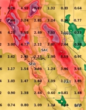
Widespread soaking rains will arrive across the northern half of California tomorrow, and will continue on and off for the next 10-12 days. Significant rainfall is also possible across much of southern California, although that will more likely come from subsequent systems. Over the course of the next 10 days, rainfall accumulations will likely be extremely impressive for late May. Total rainfall of 2-3 inches is likely *across most of NorCal,* including the lowlands; orographically favored mountain areas could see 5-6 inches or even more locally. 10-day rainfall totals will greatly exceed May monthly averages nearly everywhere; this storm sequence could easily set numerous daily rainfall records, and could singlehandedly push many NorCal sites into their top-10 wettest Mays on record. Needless to say: temperatures over the next 10 days should be well below mid-May averages throughout California. (Source)Here's a couple of graphics to go with that.

newsbuoy,
Thanks for posting that video from Juan Browne! He does the best job of reporting on conditions at Oroville Dam. One of the take-aways I got from his message was that DWR has switched from flood control to water storage. Currently, DWR isn’t planning to open the spillway until lake elevations reach 899 feet. They still have ~10’ of storage which equates to about 200,000 acre feet. Of course, if bigger than expected rains appear imminent, they’ll modify their plans.
If you look at the water elevation graph that Chris included in post #21, you’ll see that this is normally when lake elevations peak for the year. This results from a combination of lower inflows and larger outflows (normally.) Granted, the predicted weather forecast is for copious amounts of rain - especially for this time of year. Weather forecasters are lucky to get 3 days of predictions reasonably accurate, let alone 10 days.
If their forecast is correct, the DWR has tools available to increase outflows to keep dam failure at an extremely low possibility. I’m still not worried.
Grover