it is very sad, but you are exactly right…
the whole back tracing 3D CAD model is based on that assumption, and it gets even worse…
the man who is in charge of that model even propagandizes that that grazing of Trump’s ear caused the bullet trajectory to deflect from a straight line to a broken line: straight from the shooter’s muzzle to Trump’s ear, then a non-zero angle in 3D space from his ear to the railing of the right bleachers, then yet another non-zero angle in 3D space (which he admits is larger than the Trump grazing angle), and what happens after that interaction with the bleachers, he does not take into account…
so you are exactly right that he uses two pseudorandom points (the prefix pseudorandom is used because the points can be approximated, but there is no certainty whatsoever about the degrees of randomness or accuracy one can assume any further) to base his “very accurate” deductions on…
it is even worse: two weeks ago, I joined this forum, and the point where that 1st bullet interacted with that bleacher has shifted since I joined from the exact corner of the rightmost bleachers (i.e., the furthest possible point along the straight line from the shooter to the bleachers) to somewhere in between the man with the blue t-shirt and David Dutch…
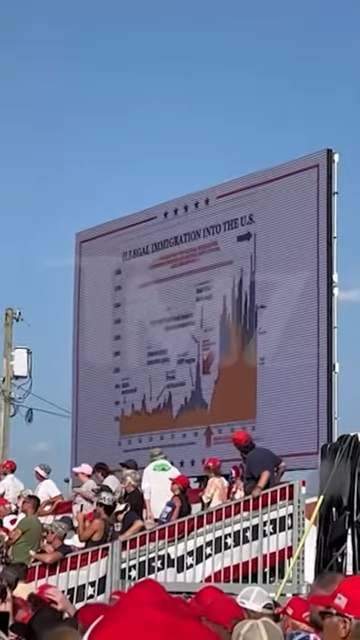
the above picture shows on the right the puffy cloud that was caused by the interaction of the 1st bullet with the right bleachers.
two weeks ago, the master of the 3D CAD model used the red-white mark on these bleachers as THE reference point for the interaction of the 1st bullet and these bleachers…
note that I stressed a couple of times the property of the assumed bullet trajectory by this man as a straight line…
until 1 week ago, he was not aware of the concept of ballistic trajectories that take into account deceleration of bullets, wind drift and horizontal drop. he even argued on this fact stating I should look into the Pythagorean theorem instead of asking dumb questions…
yet again, you are exactly right, even though I do believe that Trump’s ear got injured by that 1st bullet.
the reasons are the following:
- I went through many camera angles frame by frame and his facial expression starts showing pain at the exact moment when the bullet flew by…
- it is perfectly possible that the distance was such that this bullet would have caused a burn would that started bleeding
that is also exactly right…
as soon as I started asking questions in order to reconstruct the 3D model in a kml like format, I discovered that it did not contain sufficient information to reconstruct this reliably…
he stalls people who want to look at his model more closely, let alone validate it, and he does that by making the references not easily available…
this is a reply he gave to @sonjax6
I got many similar replies, but that were not formulated very politely…
thanks to my queries and patience and persistence, certain details have been added to this picture, and two days ago, it looked like this:
so, it took 1.5 weeks since my first request for these details before he provided more precise ground floor level values.
as you can see, the version of august the 8th states that Trump’s podium floor level was at 1337 ft above sea level, the man he labels crooks at 1335 ft and the corner of the right bleachers at 1335 ft…
2 days ago, he added the decimals I asked for for about 1.5 weeks and what turns out?
if you look at the place where he positions crooks on that roof is at 1335.15+15.4 ft = 1350.55 ft = 450.18 yd = 411.65 m. that is exactly at the roof top. as it is not very realistic to have shot from that exact roof top line, let’s round the values up with a realistic and even low-end value (considering the height of magazine, barrel and scope and some wiggle room), which becomes 1351.5 ft = 450.5 yd = 411.94 m.
in the message where he posted this updated model, he thanked me for asking these clarifications because, as he bragged, they made the back tracing model even more precise (!) and strengthened the identification of a particular vent even more!
1.5 days ago, Gary Melton from Paramount Tactical brought a great report online. even though it is still preliminary data based on his trip to Butler of last week. in that report, he shows the GPS coordinates of a survey of the area with a drone that is dedicated to geomapping, and this provides really great data…
yesterday, I summarized this information, and here it goes:
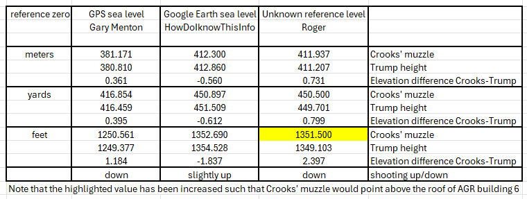
so, I have been asking for 1.5 weeks to get the more fine grained ground level data for Trump and where he places the shooter on the low roof, and you can immediately deduce what these figures mean:
even in his model, the shooter was shooting DOWNhill…
as I am using 1.2 meters (3.9 ft) as my estimate for the podium height, I am a little lower, but this does not really make a difference…
so, let me ask you a question… he puts the height of the interaction of the 1st bullet at ground floor level 1336.32+12.21167 = 1348.53 ft = 449.51 yd = 411.03 m, and Trump’s ear is allegedly at 1349.103 ft, how on earth could a back trace algorithm result in a position that is well BELOW the top of the roof of AGR building 6?
he places the interior ceiling at 8 ft below the top of the roof and the vents are a couple of inches above these ceilings…
if a rifle zeroed at 100 yards shot from that roof, the ballistic drop would have been about 6.5 inches, which is much smaller than the distance between the roof top and any of the vents or windows of that building…
so, since I deduced from the values he shows in his reference 884-5 (the 2nd 3D model shown above), that he is pushing a fairy tale (not to use the 4 letter word that @bumblebeeez does not want me to see use), and it gets even worse…
as you may have noticed, I have been asking for the references he uses to come to the ground levels he uses… in his scheme he mentions prominently “floor level 1335.15 (ref. 921) topographical KML map”, when you look up what that refers to, you come to a file on a google drive called “Trump_Rally_Butler_2024.kml”, and this defines a polygon with 44 points that specify the perimeter of the Butler Rally area, but none of these points specify their elevation with respect to whatever reference level…
so, I asked where he gets his reference floor levels from, and he points me in a very condescending manner to a youtube video that should learn me a lesson in using google earth and determining the “slop” of a hilly terrain. I am not going to point out how many spelling and grammatical errors he makes and keeps making, even after having been pointed at them… I am not a native English speaker/writer either, but at least I do my best to avoid obvious mistakes…
as he pointed me to that video, I applied the exact methodology that was shown in that video to try to bring to his attention that the ground level values that he uses (and that are allegedly derived from watching that video) do not make any sense whatsoever:
so, the yellow line in the above picture is the main road next to the rally area. based on all the bodycam and helicopter and drone footage, it is reasonable to assume that it is not a bumpy road, as what is suggested by the elevation profile he swears is an accurate representation of the elevation of the path to which it refers…
so, the question remains: where does he get his floor level values from…
anyway… I got carried away a bit ![]()
and indeed, the ad hominem arguments and many other logic fallacies are widely used to try to discredit anyone who asks pertinent questions and he tries to stall people making progress in whatever path they are investigating that is not the vent path…
all these above considerations and simple observations make me believe too that we are extremely close to being straight above target…
unfortunately for him, I am not really easy to bring off track ![]()
that does not mean that I am certain that the higher roof is where the shots have been fired from, but given all the stalling tactics that have been deployed, they certainly delayed me making progress in the addition of ballistic trajectories to my kml files…
another remarkable thing I notice in several comments is that people assume and firmly believe that the outcome of whatever model or analysis has to be adored as if it is carved in stone, and they do not realize that these models are garbage in, garbage out, and that they only take into consideration the parameters that have been used in the model…
e.g., we now know that in the 3D CAD model, the roof shooter must have been shooting down to Trump.
looking at the ballistic trajectory for someone who would have been shooting from any of the vents below that roof, that means that if the rifle was zeroed at 100 yards, the barrel should have been pointing UP with a serious angle in order to reach Trump…
but if you look at the horizontal position of the American flag above Trump and that the historic weather data Imperial, PA Weather History | Weather Underground shows wind speeds around 7-8 mph around that time, which means that the wind drift was really significant…
a little less wind, and the bullet had pierced Trump’s head…