Audio Analysis Is Most Consistent Two Shooters At Trump Rally

I’m just starting to watch this. Gary @ Paramount Tactical had a drone operator with him on his visit to Butler. He had a fancy hi-tech drone that can do 3D and mapping. This is the first video containing some of that footage.

1 Like

it is certainly true that there are things I do not know, but what about this?

let’s look at what your “manual” to determine the “slop” of a trajectory learns…

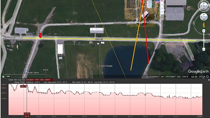
I think we can agree on the assumption that the main street next to the green of the rally area is a street which is reasonably even, not necessarily horizontal, but at least it is an even street, and certainly not humpy-bumpy up and down, right?

that street is indicated with the yellow line (near the red arrow pointing down:

well, let’s now look at the elevation profile of that path:

do you really believe that that road is so bumpy as is suggested by that elevation profile?

if you really believe that that elevation profile matches that even road, you are beyond hope…

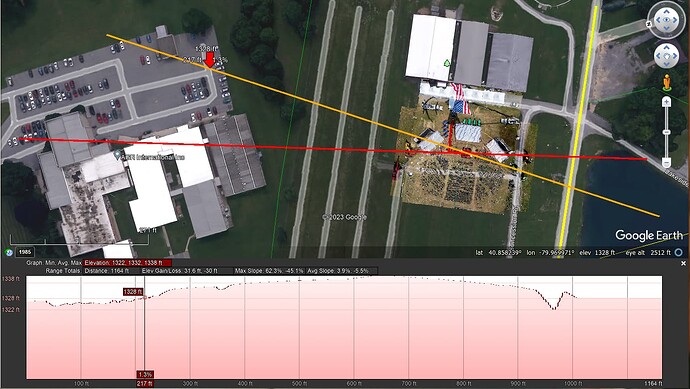
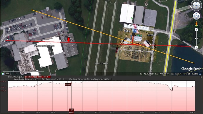
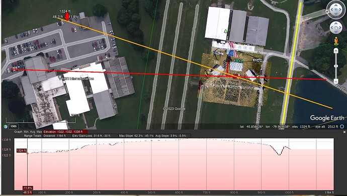
so, now let’s have a look at the elevation profile of the orange line that goes through the parking, over the location where Trump’s podium was placed and the pond:


if you honestly believe that in the above 2 pictures that first red arrow points at an elevation of 1324 ft and that second red arrow at an elevation of 1328 ft, you are beyond any hope…

now, let’s have a look at the red path through the AGR buildings:

Uploading: image.png…

do you really believe that the values are reliable, let alone make sense?

  • the pointer on the top of the highest building on this path shows 1330 ft
  • the pointer on top of the white building shows 1333 ft
  • the pointer on top of building 6 shows 1335 ft

these values do not make any sense whatsoever, and if you think they do, I have really no idea what is going on here…

if you think I am wasting your time by simply pointing out things you strongly believe in do not making sense, that is up to you, but I did everything I could to make it as clearly as possible that the reference values you swear by are not based in reality…
it is certainly true that there are things I do not know, but what about this?

let’s look at what your “manual” to determine the “slop” of a trajectory learns…

I think we can agree on the assumption that the main street next to the green of the rally area is a street which is reasonably even, not necessarily horizontal, but at least it is an even street, and certainly not humpy-bumpy up and down, right?

that street is indicated with the yellow line (near the red arrow pointing down:

well, let’s now look at the elevation profile of that path:

do you really believe that that road is so bumpy as is suggested by that elevation profile?

if you really believe that that elevation profile matches that even road, you are beyond hope…

so, now let’s have a look at the elevation profile of the orange line that goes through the parking, over the location where Trump’s podium was placed and the pond:


if you honestly believe that in the above 2 pictures that first red arrow points at an elevation of 1324 ft and that second red arrow at an elevation of 1328 ft, you are beyond any hope…

now, let’s have a look at the red path through the AGR buildings:

do you really believe that any of these elevation profile values are any reliable, let alone make sense?

  • the pointer on the top of the highest building on this path shows 1330 ft
  • the pointer on top of the white building shows 1333 ft
  • the pointer on top of building 6 shows 1335 ft

these values do not make any sense whatsoever, and if you think they do, I have really no idea what is going on here…

if you think I am wasting your time by simply pointing out things you strongly believe in do not making sense, that is up to you, but I did everything I could to make it as clearly as possible that the reference values you swear by are not based in reality…
1 Like

finally, we are starting to agree on something! Let’s celebrate!

1 Like

I am so glad you point this out, because it provides very useful independent and unbiased information:
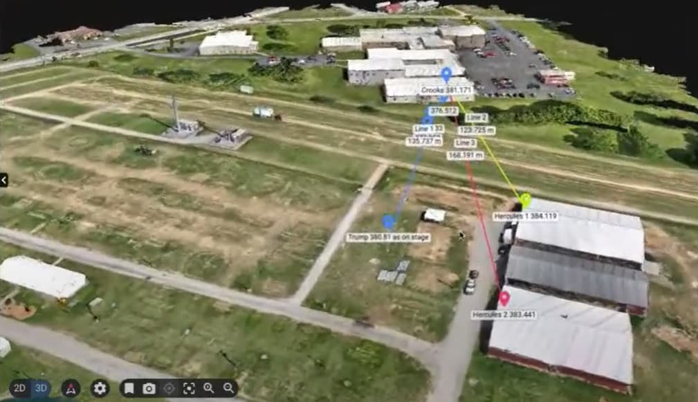
Gary shows their estimates for:

  • Trump’s ear/head height at 380.81m = 416.46 yd = 1249.38 ft above GPS sea level
  • the position of the shooter on AGR building 6 at 381.171m = 416.85 yd = 1250.56 ft above GPS sea level

they are using GPS data which refers to elevations above the average sea level.

this data was shown by Gary Melton and is preliminary data, i.e., subject to some finetuning, but is is not unreasonable to assume that it will not change by several meters :slight_smile:

what matters is the position and elevation of the alleged shooter or shooters and Trump…

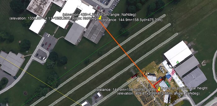
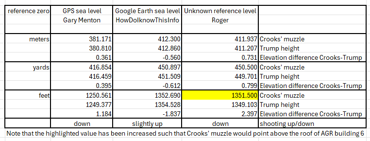
in my model, which uses google earth data, I get for these points:

  • ear height of Trump: 412.86m = 137.62 yd = 1354.53 ft above google earth’s sea level
  • man who died on the roof: 412.30m = 450.90 yd = 1352.70 ft above google earth’s sea level

based on roger’s scheme, version 884-5, we get the following values:

  • Trump’s ear position: 1337.335+11.76833 ft = 1349.10 ft = 449.70 yd = 411.21m
  • Crooks’ roof position: 1335.15+15.4 ft = 1350.55 ft = 450.18 yd = 411.65 m

in his reference 884-5, roger puts crooks right on top of the roof, which does not make sense, so let’s correct that and let’s round roger’s value up to 1351.50 ft = 450.50 yd = 411.94 m

if we put this in a table overview, we get this:

I believe it is safe to say that the vent theory that roger has been pushing the past days is highly unlikely, because if the shooter was shooting horizontally or slightly down, it it is simply impossible that the shooter would have shot from a lower position than the roof top…

I am very hopeful that Gary Melton will provide us with corroborated measurement data, and I will update and align the outcome of my model with the ground levels reported by Gary as soon as they release the corroborated data…

dear Sgt Raven, I hope you will understand that we (that means you, myself and many in this forum) have good and the best intentions to find out what really happened that day, but I also hope that you understand that when someone (e.g., myself) finds out that something is off or just plain wrong, that they (in this case myself :wink: ) do whatever it takes (sometimes directly) to bring that point forward…

bottom line: the measurements, even though preliminary, that have been reported by Gary from Paramount Tactical do NOT support roger’s model that pushes the vent hypothesis, and this model is based on seriously flawed assumptions and false data.

all I have been doing is pointing out that this model is not something that one should really put any stock in…

I rest my case, your honour…

Howdo, you come across as a bit prickly, as I might, too. Some of your posts feel like you take other posts, personally and reply as such. If so, then try and take your ego out of your posts. I try and look at things clinically, without emotion. I’m just saying. how it comes across from the other side of the screen.

Gary’s resent video shows a lot of thing better, and this is not the highest 4K resolution. Which I think will be given to him physically due to the size of the files. You might email him and ask him to show/share the 2 story building you’re interested in.

1 Like

yes, I am very aware of that.

I have been working for +27 years in a technical and research department where it is common to freely comment on each other’s models and configuration parameters, etc.

I am used to working with people where errors and anomalies can be reported freely, corrected when confirmed as errors, and then everyone moves on to the next iteration.

no hostility, no personal attacks, no egos, no repercussions, etc., are involved: when I make a mistake or when someone else points out that something is wrong, it does not matter: we correct and move on.

the models we work on evolve with time and based on progressive insights.

in one of your previous posts you said that I am a (freely worded :wink: ) arrogant bastard who is incapable of working in a team or collaborating with colleagues…
well, I have coordinated several multi-million dollar long-term research and industrial projects with industry and government sharks without any significant problems or encounters…

the reason I sometimes seem a bit irritated is because when I discover something is wrong, and people react defensively and even extremely hostile, without any good reason, it means they defend a hidden agenda…

I will hold back a little in my defense :slight_smile:

anyway. for the past 25+ years (overlapping with the 27+ years mentioned above), I have also worked as an auditor of complex systems and as a forensic expert witness for various prosecutors…

the reason why I know what I know is simply because I invest effort in researching and hands-on experience.
as you have noticed, I include references to almost everything I say, just because that is what I do when I build my case, and so far, none of the things I have been saying have been proven wrong: lots of opinions and allegations have come my way, but nobody showed me the receipts proving that I was wrong in, e.g., the elevation profiles that we have been discussing the past week or so…

the only thing that was pointed out was the numbering scheme of the AGR buildings. originally, I believed that the BCESU was authoritative in the numbering scheme. it turned out they were not, and I have adapted the scheme that seems to be more accurate. no egos involved whatsoever, a mistake is pointed out, we correct and move on…

this may give you some context as to why and how I communicate the way I do.
I am naturally very friendly and cooperative with everyone, as you must have noticed by now.

Many of the people I have worked with and I myself walk barefoot through hell and back to help each other, because they know I will help them when needed and because it is the right thing to do, but when I discover that someone is dodging bullets (hehe) when legitimately formulated questions or concerns are ignored and ridiculed, then alarm bells are ringing and we cannot let this go…

this analysis requires a combination of very advanced qualities and expertise to bring it to a successful conclusion, and I fear that some of the people who play a key role in this analysis are not qualified to do so…

my 2 cents…

1 Like

I’m not current on GPS devices as used in land survey, but isn’t it so that heights are the least precise GPS data you could rely on? To me, it happened quite often that I found my self 8 m below sealevel when in reality I was just about to board a ferry.
I really miss @sluggo2u and his LIDAR data set.

1 Like

You are very welcome.

You will see, however, if you just play around with the sliders available in the Desmos link I included in my previous message to you, that the uncertainty in the number I gave you (1715 fps) is TINY — i.e. a 2 or 3 fps. You cannot get ANYWHERE NEAR 1600 fps and still have a 220ms snik-report difference.

The physics is very simple.

It’s just a right triangle ABC.

A = shooter muzzle
B = point of bullet’s closest approach to mic
C = Mic position

AB is the hypotenuse, AC, and BC are the legs

If we define the lengths of those as:

d = AC (muzzle to mic)
y = BC (bullet closest approach to mic)
h = AB (muzzle to bullet closest approach)

And
vb = average bullet velocity
vs = sound velocity

Pythagoras tells us that

h = sqrt(d2 + y2)

Bullet travels from A to B in hvb seconds, and snik travels from B to C in yvs seconds. So the snik time is simply:

hvb + yvs

The report time is simply dvs

So the difference, which I call x in my Desmos graph, is simply

x = dvs - (hvb + yvs)

which can be simplified a bit as:

x = (d-y)vs - hvb

We know with great accuracy that:

vs = 1152 fps
y = 1.07 feet
d = 775 (at your location) or 454 (where Crooks was) feet
h = sqrt(d2 + y2) = 775.0007
x = 220 ms

Therefore turning the equation for x around, we have:

vb = h((d-y)vs - x) = 775.0007 / ((775-1.07)/1152 - 0.22) = 1715.3 fps

There is NO guesswork involved here.

QED

1 Like

would not trust TMZ (if that’s the TMZ i am thinking of)

1 Like

Only two cents?
you cant get change back.
(wink)

The simulations and models here where I work, are only as good as the input.
The problem is the hidden variables, those nasty things like temperatures, dirt, surges, humidity and outdoors, wind.
(some undetermined- and volume)
So at work, I roll my eyes at the young engineers come and wave computer simulations under my nose and say, “I have proof”.
Any of the afore mention variables can alter the results. We can’t ignore them. but it does get us close.

Most scientific dudes (PhD) don’t like their ideas or theories questioned. Its good to hear you contain and move on.

and have many worded explanations like mine to say something that could be said in fewer.

sorry, but I do like your posts.

K

2 Likes

I don’t believe anyone is investigating this and the zombie public has moved on from it to watch Kardashian reruns. We need to find out what’s behind that vent. If there’s a 2000-pound boiler up against it, we can stop wasting brain energy, but if it’s accessible that would be another check in the “still viable” column.

2 Likes

I checked the LIDAR data too and it really does not make much of a difference.

each system has a certain bias and offset.

as long as you stick to one system to compare relative heights and keep the offset in mind with respect to a reference point, different systems can be combined in parallel.

if you look at the excel sheet I posted earlier today, you will see that I do not compare the three models with each other, but only look at the internal differences, and these should be very accurate within the system itself:

  • as long as you compare GPS coordinates (lat, lon, alt) with other GPS (lat, lon, alt), you will be fine
  • the same goes for the google earth data that I use in my model
  • and the same goes for the values roger uses

but none of the (lat, lon, alt) values of any of these 3 things can be compared directly:

  • the distances measured in the GPS-based system can be compared to distances in the google earth based data and even in the system used by roger
  • the same with heights and angles

it took me over 1.5 weeks to get from roger the decimal values in feet, so now it is possible to compare apples with oranges, and what do we learn from this comparison?

in roger’s model, the shooter from the roof shot downwards, which automatically invalidates all speculation that there might have been a vent shooter, as the vents are BELOW the roof where the roof shooter may have shot from…

I have been using gps and galileo devices for car-2-car communication and car-2-infrastructure projects something like 20 years ago, and they turned out to be reasonably usable, except in areas where there is lots of iron (e.g., train stations) and close to buildings, as these devices triangulate their position based on enough stations in view.

I could easily fake my location by putting the receiver near a wall opposite an open window, and that would result in a triangulated location that was about 200 yards outside the building…

it was also easy to counterfeit gps data (not gallileo data) by recording it and playing it back inside a car, which is, e.g., handy if you want to avoid gps-fence based toll collection :slight_smile:

1 Like

thanks for the appreciation.

yes, it is a two sided sword…

the problem with this forum is that many people here have a very diverse background and the subject matter that is discussed is very fragile.

it is mostly semantics that undermine the good understanding because someone assumes they know what something means where they do not sufficiently, so I prefer to not be misunderstood and go for the more elaborate version…

and often that may end up in a longer message than originally anticipated, but so be it…

with models it is garbage in, garbage out and people do not realize that the outcome of a model does not apply to any generalisation whatsoever of its outcomes…

I prefer total transparency and that is why I provided to you all the kml file I have generated (i.e., I automated its generation :wink: ) so that everybody who wants to have a look at it can have a look at it…

that is very different to the approach that you may have observed is expected in this forum: if you do not ask for a particular reference with the appropriate reference number, you will never get anything that can be validated…

meanwhile, I know why the actual sources and references are kept hidden: a snake oil selling judas goat has taken an authoritative position…
one ring to rule them all…

in several of my posts I have made it very clear that it simply does not make sense to use two pseudorandomly chosen points in 3D space (e.g., Trump’s ear and “the” impact point at the railing to deduce any conclusive analytic outcome, but confirming that would simply undermine every previously hallucinated outcome from that model, and in order to avoid that that comes to light, I get gas lit :slight_smile:

we will see how this situation evolves…

Can you explain why? The first thing I noticed a while ago that TMZ-videos didn’t play at this site (that changed). The second was that they censored one particular important video. Therefore I was also less inclined to trust their then newly obtained “new angle” video on the southern bleacher. Obtained by whom …

I approach the audio in a less technical sense, although I do appreciate and believe that a highly technical breakdown of the timing and characteristics of the sound waves proves what the human ear can relatively easily identify.

I recall watching the immediate aftermath, moments before the event unfolded, and identifying 4 different guns. While it was very confusing in the aftermath, I had initially assumed 1 shooter and 3 different law enforcement taking him down. With more information, it’s now clear to me there were 2 different law enforcement shots, but clearly there are 2 different sets of shots by two different weapons in 2 different locations (and by default 2 assassins).

It is correct to dismiss the cruiser dashcam for anything more than the number of shots, because cars are heavily insulated and muffle sound. Anyone can watch police dashcam videos of shootings and the guns will all sound the same due to this insulation.

I’m in the camp that the deep state put this in motion with an MLK Ultra type asset (they have them all over the country on standby), provided training and instructions, and paved the way for Crooks to access the roof. There’s no other plausible explanation that lines up with the SS/Police having the worst security day in 62 years, and a simultaneously lucky break that a random assassin who has trained for a year just happens to infiltrate all security and wander around for hours and get on a roof with an AR15 within shouting distance of Trump. Incompetence is insufficient to explain the LEO failures, including a video where a man points to Crooks on the roof to an officer who simply turns and walks away totally uninterested. And the bewildering inability for a dozen officers to locate and stop Crooks, and the bewildering lack of counter snipers on that rooftop and for those in the 2 story position, their inexplicable abandonment of counter sniper posts during the exact 5 minutes Crooks needed to get on the roof and in position. It’s all beyond gross criminal negligence (that got a person killed, many injured) to the point of aiding the assassin.

And, now we’re down that path of putting this in motion and aiding him, then it is hard to conclude that the deep state would place all their chips on Crooks’ success. No, it only then makes sense that they would emplace a professional assassin in close trajectory proximity with Crooks with the same weapon, to ensure the job was done right and so that when Crooks was killed he’d be the fallguy patsy.

I see no other reasonable, plausible explanation. Very little of what we know of Crooks and his equipment and unfettered access and training every week for a year (IED van, rangefinder, drone, etc.) adds up.

There are two most probable locations to my mind, and where I would have staged a professional, and I’m about 50/50 on these positions now. We do need more evidence.

  1. Rooftop of the 2 story AGR building about 300 feet behind Crooks, that offers the same basic elevation and trajectory and only I think 3 meters taller. It was easily accessible, provided excellent observation and escape, had a façade on the parking lot side to provide for concealment, and a person in a white Tyvex suit with a white rifle could have hidden there for hours, observed the security, crown, Trump taking stage, and Crooks getting into position. Then fired 3 well aimed shots, and escaped in the confusion while Crooks fired his shots and was ended.

  2. A concealed position in AGR#6 attic area using the ventilation caps as a shooting lane. This is most supported by unaccounted for time and inexplicable disappearance of Nicols and his partner, with the former being gone some 6+ minutes and appearing 2 minutes after the shooting at the front door to AGR6. Makes one suspect he was guarding the access while his partner was getting into position, shooting, and exfiltrating.

I feel it necessary to state I’m an experienced gun owner for over 2 decades, including lots of AR15s and training and shooting experience, and qualified sharpshooter and expert on the M4 (AR15) in the Army and have multiple combat deployments. I’ve shot and am familiar with almost every modern firearm, how it sounds and operates.

5 Likes

I understand. the exact height of T ear, and the handrail, while yes, you can Trig that out. But we can’t know those two factors. Guessing won’t do. even a broken watch is right two times a day.

one ring to rule them all…

Yes, JRR Tolkien understood humanity. He saw it.

-K

Hey @greg_n now that we know where the 9th shoot came from. You can calibrate the location of the other souces at that time. this will give better accuracy for the other shoots.

Bodycam: Butler SWAT Hit Trump Shooter Before Secret Service Snipers (youtube.com)

Here is my best estimation of his position:
586760.09 m E; 4523424.99 m N; 1338ft+5ft

1 Like

Thanks again Tim,

I agree with you about the two most likely explanations. The shooter on the two-story roof has trouble with snick-boom I think. There are some people working on that. That position would I think be possible for the other audio sources, with TMZ being the most troublesome.

The one in the attic can be aligned with all sources and the snick-boom crowd. I think that is my favorite in terms of likelihood.

1 Like

These are the two hypotheses I’m going with, too. The only reason I’m considering the taller building behind Crooks is because of the energy @howdoiknowthisinfo is putting into it. I don’t believe the shot came from there, however. You’d have to be a lunatic to think you could get away with it. I’d rather make a 400-yard shot from a more concealed location. The smallness and openness of the AGR property can’t be appreciated from the footage we’re seeing on the internet. Crooks was like “Where’s Waldo” popping up on everyone’s camera. That’s because the area is so small, open, and surrounded by people. The only ones who didn’t see him were Law Enforcement. It would be the same with additional rooftop shooters.

1 Like