Hi Roger,
I have been mostly working with the Copenhaver video, and posting in the Copenhaver video thread. I figured one can look at that part of the building that’s directly behind Mr. Trump’s ear from Mr. Copenhaver’s point of view. One then adjusts for the distance between Mr. Copenhaver and the back end of the side railing of the bleachers (about 6 feet to the right and 18 inches up) and adjusts for the change in Mr. Trump’s head position.
What’s crucial is the distance between the bleachers and the podium, and then the distance between the podium and front of building 6. I can’t figure those out from your illustrations. Could you let me know what those numbers are?
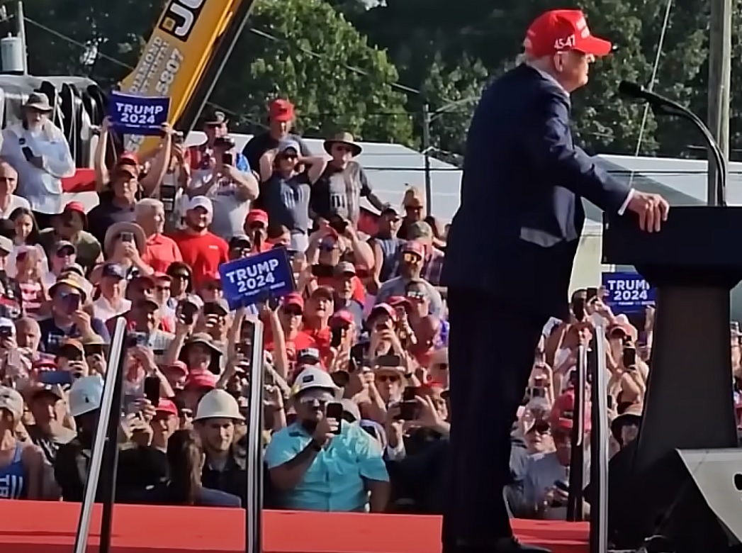
Here are the relevant screenshots for reference (the Coperhaver screenshot is rotated 4 degrees counterclockwise):
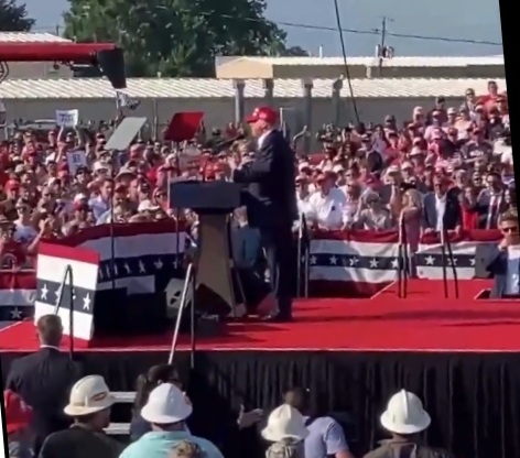
James Copenhaver is the leftmost person in the back row of the second photo, he is wearing a white shirt and gray hat. David Dutch is standing two spots to the right, also in the back row. His shirt has red and white stripes on the right shoulder and is blue with white stars on the left shoulder.
Edit to add: I think I figured it out.
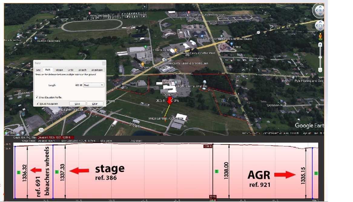
Total distance from vent in front of building 6 to corner of south bleachers is 503.18 feet, podium to corner of south bleachers is 82.28 feet, so vent to podium would be 420.85 feet. So the vent-to-podium distance to podium-to-bleachers ratio is 5.11
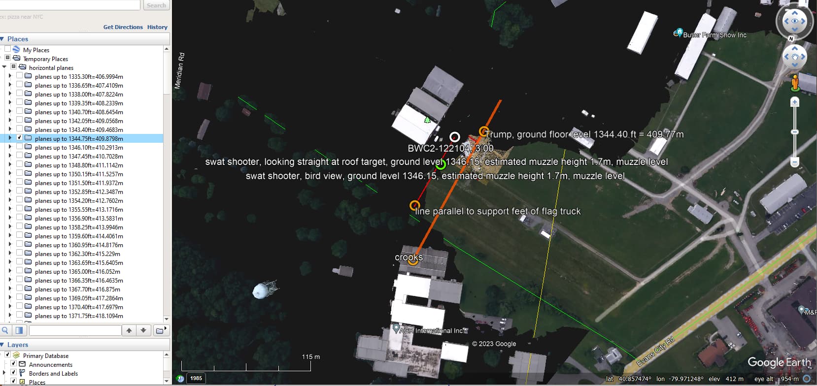
if you have eyes to see, you know the data comes from the google earth tiles.
so, where are the references and evidence that the terrain is as flat as you claim, because when you have eyes to see you can only conclude that AGR building is in a DEPRESSION, i.e., it ground floor level is MUCH lower than the ground level where the SWAT officer is shooting from, and you claim that there is only 2.185 ft = 66.6 cm…
apart from this being a very remarkable number, it is MUCH too LOW.
when I blacken out the area below the ground floor level of the location where Trump had his podium, which was 13440.40 ft = 409.77m, I get the following view in google earth:
in your picture labeled 884-5 you mention that the top of AGR building 6 is 15.4 ft from the floor.
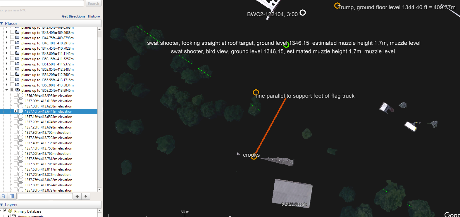
I know that google earth reports 1357.10 ft = 413.64m as the height of AGR building 6 as all the areas that get blackened out at that level include parts of that building’s roof top.
to avoid discussion, I blackened out a level that still keeps a part of the roof visible such that you can confirm that it is that roof at that level:
so, when we subtract the height of that building 15.4 ft, we get at a floor level for building 6 at 1341.7 ft
this leads us to:
ground floor level of AGR building 6 based on google earth data = 1341.70 ft = 413.64m
ground floor level of Trump’s podium based on google earth data = 1344.40 ft = 409.77m
difference between these ground floor levels = 2.70 ft = 82.296cm.
so, the difference between your and google earth’s floor levels of Trump’s podium and the floor level of AGR building 6 is about 0.515 ft = 15.70 cm.
that is not too bad as an offset, so we agree on the differences between the floor levels of Trump’s podium and the floor level of AGR building 6.
what we do not agree on is the actual values, because they simply do not match anyone’s observations when validating your scheme with what we see in google earth:
the ground level of AGR building 6 cannot easily be established due to the parking (which is not level) and the number of steps in front of that building, but the ground level of Trump’s podium can be easily established, and google earth reports it at 1344.40 ft = 409.77m
you specify this value to be 1337.335 ft, which is 7.065 ft = 2.153m LOWER than what google earth reports. that sort of differences is no longer due to rounding errors…
so, the question becomes: show me whatever actual documentation you use to come to the 1337.335 ft level of the location where you put Trump’s podium…
and referring to a document which is not accessible to me is not something which is trustworthy…
for everything I have been saying, I have given you supporting images, video and explanations.
so, show me the evidence that Trump’s podium was put at 1337.335 ft and that it is not the level 1344.4 ft as reported by google earth…
an image of which I cannot determine the provenance or which I cannot verify or reconstruct otherwise is not a reference document…
I need the tangible input and be able to reconstruct that elevation profile which you have annotated in this picture before it can be considered anything else than an allegation…
until you provide me with this evidence, the floor levels you are using and stating in your 884-5 are about 7 ft = 2.15m TOO LOW!
Does this information align with Chris’s echo data? Do you suspect the muzzle was poked through the vent, or behind (inside) the vent? If you believe your back tracing is correct how do you (we) prove the shots came from there?
But if you had a microphone that was 775 ft from the shooter muzzle, and there was a snik-report difference on that microphone of 220 ms, and the average velocity of the bullet was 2622 fps from shooter to point of closest approach to the mic, then the bullet would be approximately 173 feet away from the microphone at point of closest approach.
So if you are talking about Trump’s mic, this is NOT possible. Because the bullet was only 1.07 feet awat from mic at closest approach.
so, what would the average velocity of the bullet have to be in order to have that difference of 220ms if the shooter was 775 ft away from the microphone?
I have not yet done sound analyses, hence my crippled terminology, but I am getting to that analysis after the ballistic trajectories that I am adding to my kml files…
from your username we can deduce you are involved in law enforcement or the military.
in either case, it would not surprise you that facts and the corroboration of information is very important before we can come to whatever conclusion.
the first time I was shown the 3d model, I found it odd that the floor levels that were mentioned were all round values in foot, and that these values did not match what I observed when checking google earth. I am open to accepting that google earth is not a perfect reference, but the difference that I observe is a non-negligible 7 ft = 2.1 meters…
so, that is how it all started: I started asking where that vertical offset came from…
now, just less than 2 weeks later, roger adjusted version 5 of the 3D model with higher precision floor level values, which reduce the uncertainty and increase the precision of the model from 30 cm (1 ft) uncertainty to 0.01 ft, which is a great improvement, and as you may have noticed, this updated version allows me to confirm that the vertical difference between the ground floor level of AGR building 6 and the ground floor level of Trump’s podium is more or less negligible: the difference between these two ground levels in roger’s model and in my model is about half a foot, and that is fine by me.
so, the only thing we still are not clear on is the overall vertical offset, and this is very important, because the values that roger is using are 7 ft = 2.1 meters lower than what you would get from google earth… that is much more than a rounding error…
I am simply trying to recreate the 3D model in google earth, and this fails due to discrepancies…
you can call this whatever you want, but if the model that is used to evaluate possible shooter locations cannot be verified and does not seem to match reality, I think there is something wrong with that model.
you call this criticizing, but it is nothing more or less than an attempt to check whether the model is valid or not, and I think you cannot disagree with the necessity that claims are underpinned with unambiguously solid evidence.
every time I ask for the elevation data, I get the same reply: we are using the topographic KML map from Land ID.
I have no access to this “topographic KML map from Land ID”, which means that (1) I cannot validate whether these values are plausible, and (2) I cannot confirm that roger is using this map correctly…
in some posts there was a link to a google drive file called “Trump Rally Butler 2024_.kml” which is supposed to be a precise representation of the rally area, well, I checked that file, and it contains 44 points with longitude and latitude values without altitude/elevation values, so that file cannot have been used to deduce the elevations of either the AGR building(s) or Trump’s podium or the bleachers either.
I prefer a direct approach to avoid ambiguity, so I ask direct questions.
you may see that as inappropriate, but that is not how I see it, I just want clarity about things and if people avoid answering simple and direct questions, that is highly suspicious.
as you may have noticed, it took about a week before I got the answer to the very simple question about the angle between the line of sight from the roof top of AGR building 6 and the podium.
in a 3D CAD program, it takes seconds to visualize that angle, yet he stalled me for about a week.
I would be surprised if you would take that for granted…
and instead of being open minded and encouraging different the analysis of views while analyzing this ballistics puzzle, he tries to steer everybody into the vent direction which is not the most realistic one if you ask me…
based on the very valuable feedback you have given with several of your posts, I can deduce that you have plenty of gun knowledge and expertise, so let me ask you an open question, based on all the information that you have seen passing by and your expertise and knowledge: what is the most likely scenario for what happened during that day before, during and shortly after the assassination attempt in regard to the actor or actors that shot at that rally?
as a matter of reference the first version I saw of the 3D model (this model is very imprecise and does not allow any corroboration whatsoever):
yesterday’s version of roger’s 3D model includes much more detail which almost enables its validation (which implies that it is still impossible to confirm that it is a valid representation of reality):
So, your heights reference is Google Earth, by simply pointing with the mouse? Are you serious?
So, if you point to the roof of the ARG building 6, you will get the height of the top of the roof, right? But we need the height of the floor, not the height of the roof!
I suggest you quickly go back and take my suggested crash course which I posted here on August 6:
Once you have leaned that, then you can go to the next level, by importing the Land ID KML file into Google Earth, then finally you will start getting the same numbers I am using as a reference.
I don’t want to pick a fight, but I must mention it again:
The fact that you are using the poked hydraulic hose (which is the third impact point, Trumps ear 1, bleachers 2, hose 3) as your reference point
The fact that the bleachers and trumps ear are approximately the same height (in absolute) makes the bullet trace almost horizontal, like I mentioned in my first post to you, your back traced shot will never make it to the height of the roof you are referring to
The fact that you simply click on the heights with Google Earth, using the most primitive way
Leads me to say, that your knowledge is insufficient to make such “back – tracing” calculations. Therefore, your usernames question is justified:
howdoyouknowthisinfo? of which I would answer, you don’t…
the bullet’s deflection while grazing Trump’s ear is very minor, as I have shown you with the recreation of that grazing as recorded with a 100.000 fps camera…
the deflection of the bullet due to its interaction with the railing of the bleachers is unknown. if it was grazing that railing it may have been minor, if it was a penetration, it would have been major.
we simply do not know.
what we do know is that the 1st bullet punctured the hydraulics of the hydraulic lift, and that hydraulic lift happens to be in an almost straight line between the alleged roof shooter, Trump, the corner of the right bleachers and the hydraulic beam…
so, that is what we do know, and I use simple observations to come to these observations…
that is how I know this information…
and this also implies that it does not really matter which point would be used for that back tracing, as each of these points lie on almost the same line…
the reason why I am using the hydraulic beam as the reference is twofold:
the location of this beam can be established much more precisely than Trump’s or the bleacher’s impact…
the distance between Trump and the hydraulic beam is larger, which enhances precision when extrapolating to greater distances…
so, where can I download that Land ID kml file from?
I think there are only two hypothesis that should be considered:
Crooks shot all 8 shots
Another shooter shot 1- 3 and Crooks shot 4 -8
In the beginning Chris immediately pointed out in his YouTube the two different gun shots noises, one muffled and one with echoes. Just by using my common sense, and looking at his data I agreed with Chris.
1:0 for hypothesis 2
The fact that we are very lucky to have the first bullet grazing Trumps ear and then hitting the bleachers corner locking two points in space, I and a big portion of this community took the challenge to “back trace” the bullet. This would be another indicator which hypothesis is more likely. If the back traced bullet leads back to Crooks within a reasonable error rate, we could consider hypothesise 1 to be correct, making it 1:1 and making it a toss-up. But with all efforts done and everybody debunking or improving our two points defined in space, makes it impossible that Crooks could have made that shot. You know, nobody has given us plausible two points in space that would lead back to Crooks. If somebody has that data, we, in this forum would be very glad to evaluate it.
So, it is 2:0 for hypothesis 2
So now we assume by the noises of the gun there are two shooters, our back traced bullet narrows it down from where this shot was coming from, excluding the water tower, the woods and many other places. It is sure it is coming from building 6, most suspect being Vent 3 at this moment. That points to the needle in the haystack. Now we just need to find the needle by analysing all videos we have and concentrate on Vent 3 and a bit of the surroundings. The back traced bullet is very powerful information, because you simply can’t analyse all of the videos and all of the points. We are focused on a very specific place now.
So this brings us to our status of today and if you look at my latest post, it seems very very likely that a serous amount of photo shop has been applied on the entire wall of building 6, which confirms that we are on the right track and over the target:
3 : 0 for hypothesis 2
Everybody should help and analyse the wall of building 6. The needle is hidden there…
I’m just starting to watch this. Gary @ Paramount Tactical had a drone operator with him on his visit to Butler. He had a fancy hi-tech drone that can do 3D and mapping. This is the first video containing some of that footage.
it is certainly true that there are things I do not know, but what about this?
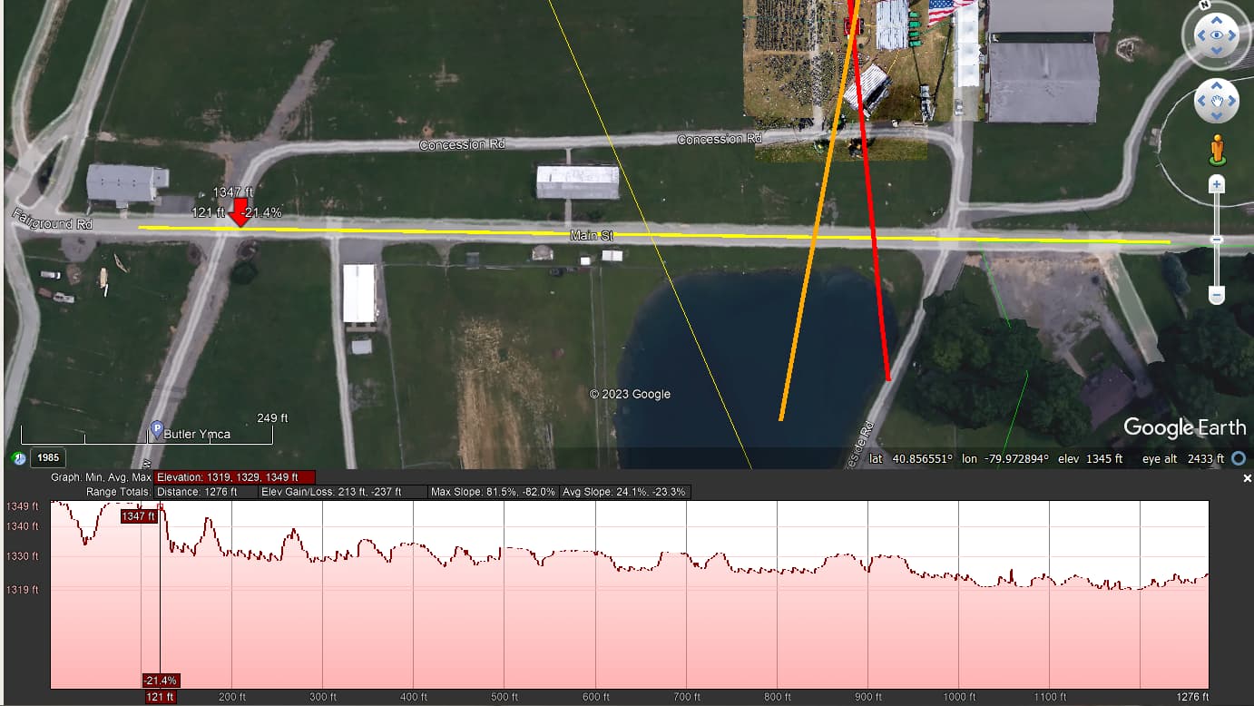
let’s look at what your “manual” to determine the “slop” of a trajectory learns…
I think we can agree on the assumption that the main street next to the green of the rally area is a street which is reasonably even, not necessarily horizontal, but at least it is an even street, and certainly not humpy-bumpy up and down, right?
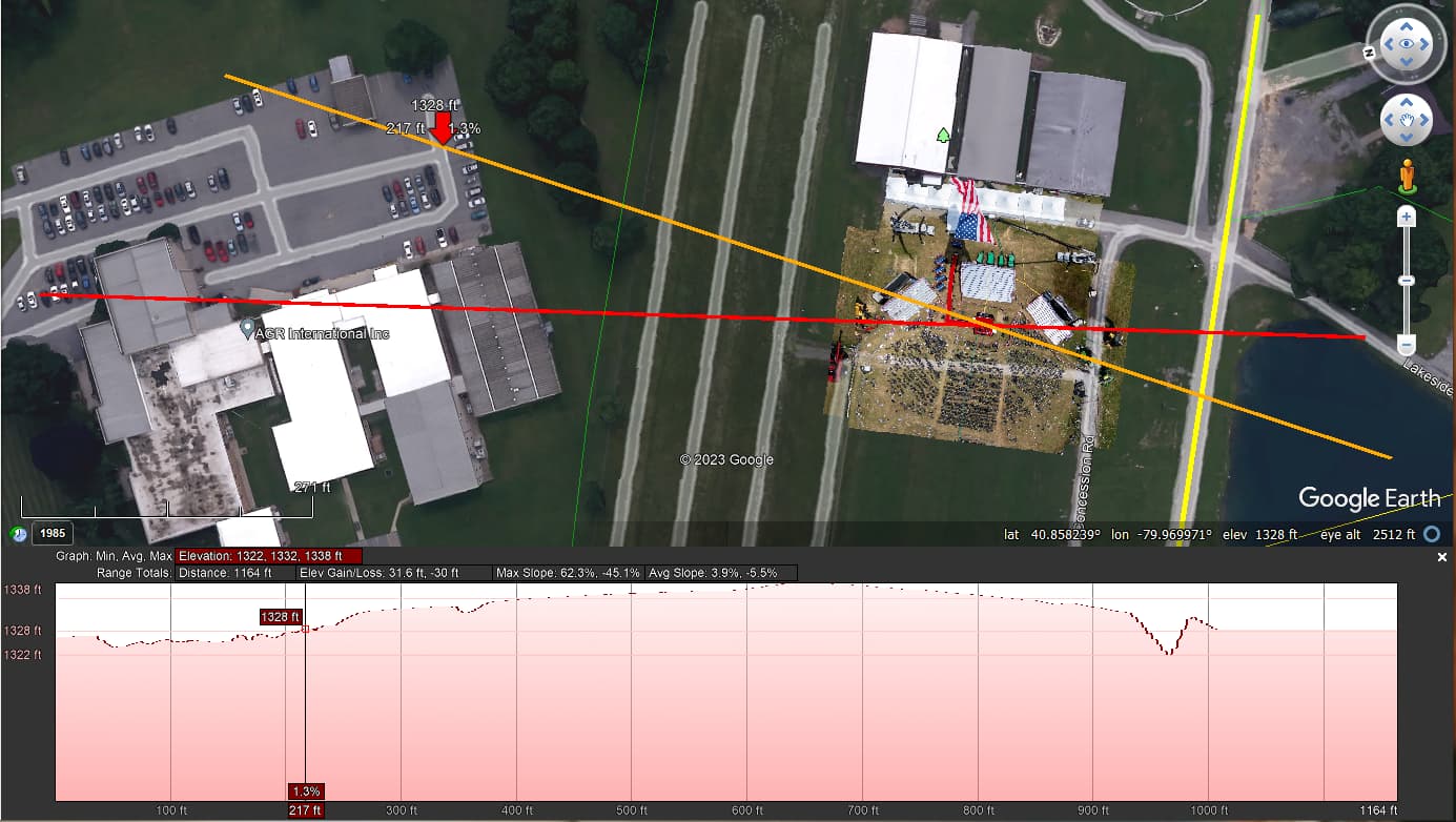
that street is indicated with the yellow line (near the red arrow pointing down:
do you really believe that that road is so bumpy as is suggested by that elevation profile?
if you really believe that that elevation profile matches that even road, you are beyond hope…
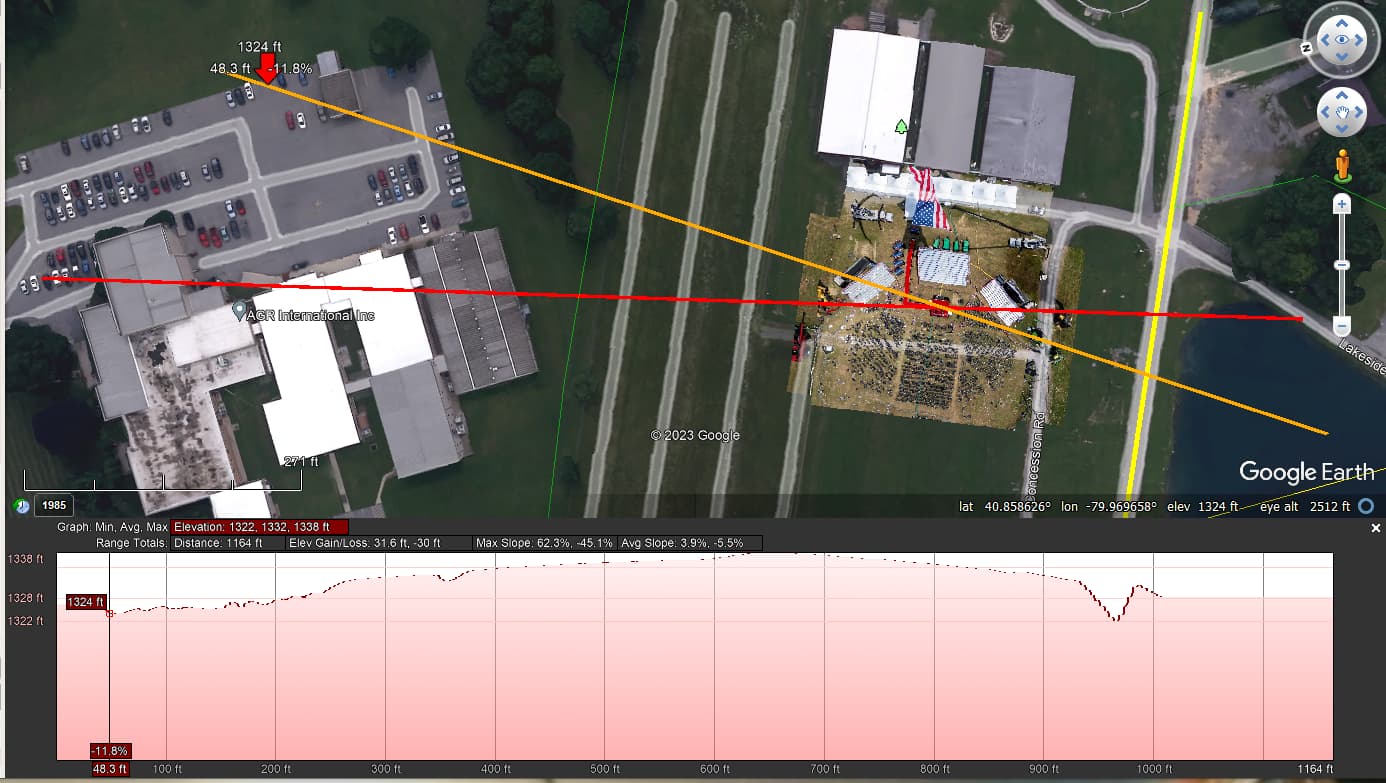
so, now let’s have a look at the elevation profile of the orange line that goes through the parking, over the location where Trump’s podium was placed and the pond:
if you honestly believe that in the above 2 pictures that first red arrow points at an elevation of 1324 ft and that second red arrow at an elevation of 1328 ft, you are beyond any hope…
now, let’s have a look at the red path through the AGR buildings:
do you really believe that the values are reliable, let alone make sense?
the pointer on the top of the highest building on this path shows 1330 ft
the pointer on top of the white building shows 1333 ft
the pointer on top of building 6 shows 1335 ft
these values do not make any sense whatsoever, and if you think they do, I have really no idea what is going on here…
if you think I am wasting your time by simply pointing out things you strongly believe in do not making sense, that is up to you, but I did everything I could to make it as clearly as possible that the reference values you swear by are not based in reality…