Site Reconstruction of the Assassination Attempt

1 Like

Thank you for all your good feedback! We are getting more and more accurate thanks to this community. I have taken into consideration all the new factors we have gathered and entered the new vertex parameters and back traced the bullet. Surprisingly though the trace got closer to the patch rather than to the shooter on the roof. At this point I would like to challenge anybody to prove that this simulation is not accurate. If you have any proof that some number can’t be correct, I will gladly change the vertex parameters and backtrace the bullet again. I am fully transparent to share any documents that backs up my numbers. I am also willing to give you a SW, IGES or STEP file of this model if somebody wants to import it into their CAD system. I am your disposal……

2 Likes

Hi Roger, do you have Trump standing dead center of the stage? i could be wrong but it looks like Trump should be a bit closer to the front of the stage. See this video with two timestamps that should help giving a precise location of Trump’s head:

Second timestamp is at t=433 to see where Trump’s head is relative to the microphone.

checking in gimp it looks like the back of his head would be around 55% from the back of the stage, but that’s just a rough guess.

1 Like

Thanks for your feedback. I was looking for a good side view and this helps a lot. Good job! One thing that should be mentioned is that the centre of the cylinder representing Trump is taken from his ear. I did that because it is easier from a drawing point of view. So, if you want to image the body it would be closer to the mic. Another factor is that he is looking back to the screen putting the ear more to the back. I might take the time and simulate his body and his ear, so that there are less confusions. Another thing to consider is when the secret service jumped on him, they moved the mic. So, I would even have the tendency to move the point more towards the back, which would put the impact point even closer to the patch. Looking at the below screenshot from the top view and comparing with the video, I think we can leave the position the way it is?

1 Like

while I am drawing the head of Trump, something came to my mind which was called out by John Cullen very early into the investigations (credit to him) Trump is looking back to the screen. Therefore, the ear is protected by the cheek. Assuming we have huge position error with the corner of the blister (which we of course don’t have), the shooter from the roof can’t hit Trumps ear without damaging the cheek. It is of course difficult to determine the exact angle of Trumps head, but I just drew a dotted line towards the corner of the screen. This is just some information I wanted to share…

2 Likes

I think his head should be moved so that its right next to the outline of the podium. Maybe even slightly overlapping it. This angle from the video looks very close to what his position was when the first show clipped his ear.
TumpePodium
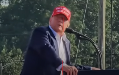
And this is the view of him right as the first shot clips his ear from the RSBN video. His head is turned almost perfectly parallel with the podium.
TrumpFirstShot
I checked the pixels of the podium’s position on your picture of the blister and it is correct. It matches with the side video. But Trump’s head should be closer like i mentioned above.

So people can check, I measured the blister in the side video as 1024 pixels, and the edge of the podium as being 598 pixels from the back of the blister. In your overhead shot, the podium is 327 pixels, and the podium is 188 pixels from the back. Give or take a couple pixels for each measurement.

I have used a google API to get approximate ground elevations. (Note: I may delete the map in a few days). Here is the link that show the points I sampled and their elevation according to Google. Also, here is the raw output from the google API…

{
“results” :
[
{
“elevation” : 407.0099487304688,
“location” :
{
“lat” : 40.85808,
“lng” : -79.97056000000001
},
“resolution” : 2.385987997055054
},
{
“elevation” : 407.6414184570312,
“location” :
{
“lat” : 40.85794,
“lng” : -79.97068
},
“resolution” : 2.385987997055054
},
{
“elevation” : 407.8505859375,
“location” :
{
“lat” : 40.85787,
“lng” : -79.97074000000001
},
“resolution” : 2.385987997055054
},
{
“elevation” : 408.0685119628906,
“location” :
{
“lat” : 40.85767,
“lng” : -79.97081
},
“resolution” : 2.385987997055054
},
{
“elevation” : 408.1244506835938,
“location” :
{
“lat” : 40.85751,
“lng” : -79.9709
},
“resolution” : 2.385987997055054
},
{
“elevation” : 408.2221069335938,
“location” :
{
“lat” : 40.8574,
“lng” : -79.97098
},
“resolution” : 2.385987997055054
},
{
“elevation” : 407.7518920898438,
“location” :
{
“lat” : 40.85715,
“lng” : -79.97105999999999
},
“resolution” : 2.385987997055054
}
],
“status” : “OK”
}

Hi Sluggo,
I’m in the process of creating a CAD drawing of the trajectory of the first bullet in the Trump assassination attempt using your elevations. I’m completely unfamiliar with LiDAR. Is that the source of your elevation data?
What I’m having difficulty reconciling is your ground elevation at Building 6. I know it’s not much (it’s all that I have to go on) but Google Earth indicates that the elevation on the south side of the building is 1337. The unknown architect that Chris quotes claims the building to be about 15’ 5 3/8" tall at the west end. My best estimate is 15’ 2 3/8" plus the ridge cap, so about the same. Your data, I believe, seems to indicate that the elevation “behind the peak where the shooter’s body was located (is) 1350.2 ft”. Are you saying that the peak of the roof is 1350.2 or that’s the elevation where his body was located? Head or feet? Then you go on to say in the next line “estimate shooters profile above peak at 1.5 ft 1351.7”, the top of his head or the barrel of his rifle? The elevation that I understand you to assert at the peak of the roof is 1350.2 (and the shooter raised up 1.5’ above it). If I subtract the height of the building (15’ 5"±) that means that the ground elevation is 1334.75, 2.25’ below what Google Earth indicates. I didn’t see that you specified what the ground elevation is on the south side of Building 6. Does LiDAR indicate something different than 1337?
Anyway, I don’t mean to be a stickler for details, but I am. 2.25’ in elevation, whether on the ground or on the roof makes a big difference in trajectory. I’m just trying to be as accurate as possible and understand your elevations. By the way, I was the one who found and supplied the Speedy Bleachers drawing, and the height at the top of the back railing is 11’ 2 1/2", not 11’.

The 1350.2 elevation is beyond (north) of the peak approximately where the shooter’s head supposedly was. 1351.7 was an estimate of where the shooter’s head would be above the point noted above.

The ground elevation south of the building is around 1337 but the terrain dips to 1334 starting at 1337 30ft from the building and sloping down toward the building, leveling off to 1334 about 10ft from the building. The building footprint is carved out of the surrounding terrain.

Source of data is USGS National LiDAR Dataset. I downloaded the LiDAR and made the DSM from it.

You want me to export an XML file for you so you can bring the surface into CAD?

1 Like

Roger, quick question. What is the distance you have for Crooks’s location on the roof to Trump’s head?

Hi guys,
Thanks for all the feedback. The more we are the more accurate we get. Just to clarify, we should all be using the same software to avoid many questions and discrepancies. I have found that “Google Earth Pro” has the best ability to exactly point to the points of interest and to get the exact elevations. Please go ahead and download Google Earth pro for free, enter “Butler Farm Show Airport” in the search. There you can find our place of interest, then simply click the ruler and don’t forget to activate in the Path tab “Show elevation profile” Set the path of interest and you get the results as images below.

Hi Arthur,
449.79

1 Like

Ground elevation of AGR building is 2 feet LOWER than Pres. Trump stage area.

Map website: Elevation Finder

Hi Sluggo,
I simply used the drawing from Chris’ video (see below). I set my point on the peak of the roof. I would be glad to be more accurate if you have further information what needs to be added.

As for the back railing, yes it is 11 2 1/2, but if you look at the video, the impact is lower. See my post 127

Yes, that’s exactly what I have indicated, I added 2 feet to the stage hight, also you can see it in my excel sheet that I added 2 feet to stage hight

Hi Arthur,
Yes, I agree, he is a bit too far away. I will change his position for the next simulation. Another person drew my attention that when you get measured you have a straight back. Older people tend to have a lower posture as you can see in the below picture. Therefore, I will move Trump more towards the mic and decrease the height of his ear a little.

1 Like

I come up with 15.5 and 12.21. I’d say those numbers are pretty solid. :grinning:

One more suggestion would be to create a somewhat larger circle to represent a range of possible ear locations. This would account for the uncertainty. Then you can model all the shots that could pass through that circle - as opposed to the one shot that would hit a precisely placed and small ear target.

Hi Arthur,
It was a good idea you had, and we can stop looking just after the first circle! If you simply trace Crooks bullet to the bleachers you see that the line crosses the Mic stand, making it impossible to place Trumps right ear next to it. Everybody at home is able to verify this by printing out the top view and using a ruler and pencil.
Either we are completely missing something, or we can prove that Crooks could not have shot Trump in the ear and hit the bleachers.
I have a small doubt that Crooks position is not correct because I took a helicopter view from Sky news. Now with the good drone video, I will be able to determine the position of Crooks more accurately. I will double check his position and trace the line again.

1 Like